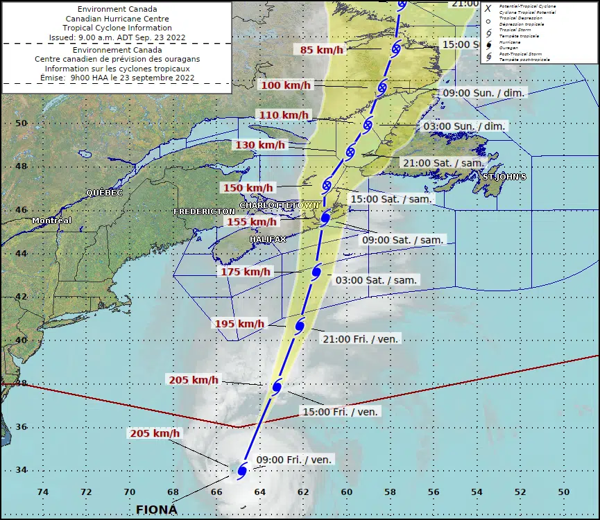
It looks like our region will see more wind than rain from hurricane Fiona, according to forecasters.
Jill Maepea, a meteorologist with Environment Canada, said conditions will start to deteriorate on Friday evening.
“It will be overnight tonight that the worst conditions are anticipated, generally between 3 a.m. and 8 a.m.,” Maepea said on Friday morning.
A tropical storm warning and a wind warning have been issued for Saint John, the Kennebecasis Valley, Sussex, Queens County, Grand Manan, and coastal Charlotte County.
The Canadian Hurricane Centre said wind gusts near 100 kilometres per hour are expected between late Friday evening and noon on Saturday.
“These winds could break large tree branches resulting in downed utility lines. Some damage to signage and roof shingles may also occur,” the centre said in a statement.
There are no wind warnings in effect for Charlotte County, but wind gusts are still expected to reach 70 kilometres per hour.
As for rainfall amounts, the latest forecast calls for about five to 10 millimetres in Saint John, the Kennebecasis Valley and Sussex. Charlotte County will only see isolated showers.
In New Brunswick, Fiona will have the biggest impact in southeastern regions, including Greater Moncton.
Between 60 and 80 millimetres of rain is expected to fall in those regions, with local amounts possibly reaching 120 millimetres. The rain will also be heavy, with more than 20 millimetres per hour possible at times.
A storm surge warning is also in effect for the eastern coastline of New Brunswick. Maepea said the storm surge is expected to coincide with high tide on Saturday morning.
“We are expecting some coastal flooding and waves generally between as high as six to eight metres,” she said.
NB Power crews are on standby and anticipate impacts and outages to New Brunswickers as a result of Fiona.
The utility currently has over 400 field resources available to respond in all districts when outages occur.
These resources are NB Power crews and additional contractor crews, who are on hand as a precautionary measure.
At 11 a.m. Friday, the centre of hurricane Fiona was located about 405 kilometres north of Bermuda and 970 kilometres south of Halifax, according to the latest update from the National Hurricane Centre.
Maximum sustained winds are at 215 kilometres per hour, making it a strong category 4 storm, and it is moving to the northeast at 56 kilometres per hour.
The centre of the storm, which the Canadian Hurricane Centre said looks to be a “historic” event for eastern Canada, is expected to make landfall in eastern mainland Nova Scotia or Cape Breton early Saturday.
In Nova Scotia and Prince Edward Island, which are expected to see the brunt of the storm, some areas could see up to 200 millimetres of rain, wind gusts up 150 kilometres per hour, and waves of eight to 12 metres in height.
You can find the latest details from the Canadian Hurricane Centre by clicking here.
🌀 The 3 AM ADT updated track and bulletins have been issued for #Fiona. #Hurricane and #TropicalStorm WARNINGS are now in effect for what looks to be a historic storm for eastern Canada. https://t.co/QURfkCQp7W
— ECCC Canadian Hurricane Centre (@ECCC_CHC) September 23, 2022


