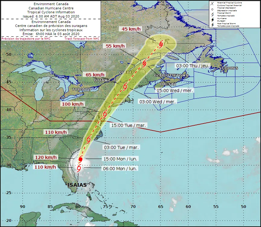
The forecast track of tropical storm Isaias issued by the Canadian Hurricane Centre at 6 a.m. AT on August 3, 2020. (Photo: Canadian Hurricane Centre)
We could be in for some wet and windy weather later this week thanks to tropical storm Isaias.
Located just east of Florida, the storm is expected to track up the U.S. East Coast over the coming days.
The Canadian Hurricane Centre says Isaias is expected to move into our region Wednesday or Thursday.
But meteorologist Darin Borgel says it is still too soon to say what the exact impacts might be for New Brunswick.
“There’s still a wide range of scenarios for Canada at this time,” said Borgel. “Nothing too, too severe, likely nothing like out of Dorian or anything like that.”
Hurricane Dorian blew through the province last September with wind gusts of more than 95 kilometres per hour, leaving more than 80,000 homes and businesses without power.
Borgel said the gustiest normally occur near the track of the storm with the heaviest rain usually falling to the north of it.
But with the storm still a few days out, it is still too soon to say where exactly the storm will track, he said.
According to the 6 a.m. AT Monday update from the Canadian Hurricane Centre, the “cone of uncertainty” or probable track ranges from northern New Brunswick to parts of Quebec.
Borgel said the forecasted track of Isaias has been shifting further inland over the past few days, which could be good news for us.
“Tropical cyclones feed primarily being over the ocean, and once you kind of cut off that feed, you won’t add any more fuel to the fire, so basically they’re only carrying the moisture that’s already with it,” he said.
Borgel said the Canadian Hurricane Centre will begin issuing regular updates on Isaias starting Monday. He encouraged residents to keep an eye on the forecast over the coming days.


