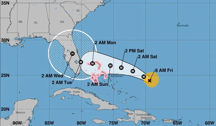
The latest projected track of Hurricane Dorian from the National Hurricane Centre, as of 8 a.m. AT on Aug. 30, 2019. (Photo: National Hurricane Centre)
Environment Canada is keeping a close watch on Hurricane Dorian as it tracks toward Florida.
The category 3 storm is due to slow in the coming days, gaining intensity over warm Caribbean waters.
Meteorologist Bob Robichaud says they have “pretty good confidence” on the track out to about three days, but that is when things are more uncertain.
Robichaud says they are monitoring two potential scenarios, including one which has the storm turning to the north then northeast from Florida.
“That’s the scenario we’re going to have to keep an eye on, but at least for the immediate future, it doesn’t look like Dorian will have much of an impact here in Atlantic Canada, at least at this point, but we’re certainly watching it very closely,” said Robichaud.
Take a look at all that lightning! The Geostationary Lightning Mapper aboard NOAA's #GOESEast captured this view of all the lightning associated with #HurricaneDorian2019 in the morning hours of Aug. 30, 2019. Follow the storm's path here: https://t.co/raWlm8629m pic.twitter.com/qxOMNmzXIq
— NOAA Satellites (@NOAASatellites) August 30, 2019
All of Florida is under a state of emergency and authorities are urging residents to stockpile a week’s worth of food and supplies as Dorian gathers strength and aims to slam the state as soon as Monday as a Category 4 storm.
In a tweet, the U.S. National Weather Service said Dorian could bring a “triple-threat of dangers” to the state, including a “life-threatening storm surge, devastating hurricane-force winds and heavy rains.”


