Parts of the Maritimes could feel the effects of a tropical storm later in the week.
Tropical Depression Six formed off the east coast of the United States late Monday.
It is expected to become Tropical Storm Erin on Tuesday, according to the Canadian Hurricane Centre (CHC).
Forecasters issued a tropical cyclone information statement on Monday evening for Nova Scotia, Prince Edward Island, and southern and southeastern New Brunswick.
“The greatest impact from this system will be rainfall, which will very likely meet or exceed warning criteria (50 mm or more in 24 hours), especially near or northwest of its eventual track through the region,” said the CHC in a statement Monday evening. “Maximum rainfall could exceed 100 mm in some isolated areas.”
The tropical system was located about 500 kilometres southeast of Cape Hatteras, N.C., as of 9 p.m. Atlantic Time.

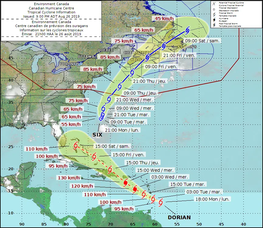
The latest projected track of Tropical Depression Six, which formed off the east coast of the United States on Monday. Click on the photo to see a larger version. (Photo: Submitted/Canadian Hurricane Centre)
The centre of the storm is expected to stay well off the coast of the United States, according to the latest track map from the CHC.
But the map suggests the storm could make landfall along the coast of Nova Scotia late Thursday or early Friday as a tropical storm or post-tropical storm.
“As T.D. Six has just formed, and likely won’t begin affecting Canadian territory until later in the week, details on impacts for Atlantic Canada are too far off to specify at this time,” said the CHC. “Most of the impacts will depend greatly on the exact track the system takes through our region.
Environment Canada’s latest forecast for southern New Brunswick calls for showers on Thursday, periods of rain on Thursday night, and clouds on Friday.


